Tell es-Safi, Israel, Summer 2004
Tracking the Trench
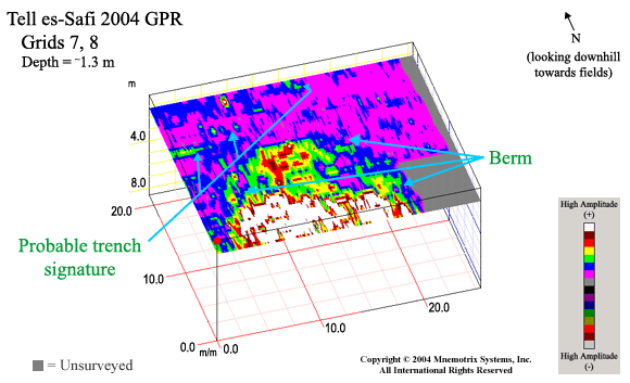
Grids 7 & 8:
Click for GPS Coordinates
The raised berm area, which would have been the area
"behind" where the trench was being dug where the earth
was piled up, showed the most distinct anomalies in this GPR
survey, and extended several meters in depth. Note that elevation
information of the bumpy topography has not yet been taken into
account or factored in for correct depth notations throughout,
which means the depth is an estimated "uniform" depth.
In these areas we followed the sub-surface anomalies north
and across the modern-day dirt road. While the trench signature
seemed to disappear under the road, probably due to impacted
soil conditions, it can be faintly seen again on the north
side of the road. These signature points can be drawn in
on the map to determine the course of the trench and
plot its probable continued course beyond the surveyed area.