Did you know that Jerusalem is mentioned 767 times in the King James Version of the Bible? As in Psalm 137 we are often reminded to keep Jersualem's memory alive. Click here to browse the 767 references to Jerusalem throughout the various Books of the Old and New Testaments, a bastion of faith for the Judaeo-Christian world. You don't have to be religious to recognize Jerusalem's importance to Western Civilization
As technology has become available to support archaeology,
we have been able to go where only science can lead us. Mysteries
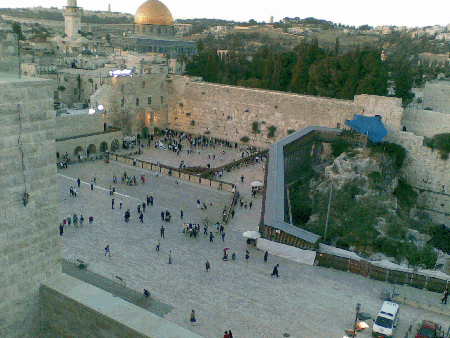
of the Old City of Jerusalem have lay waiting for years,
now ready to reveal themselves to the scrutiny of
advanced techniques.
Having focused her doctoral research on such studies from
2003-2009, Dr. Jessie A. Pincus
returned her attention in the summer of 2010 to completing a project begun
in 2003: the Underground Jerusalem Heritage Trail.
Mapping Underground Jerusalem with GPR and GIS
Since 2003 Jessie has been working to create a sub-surface map of the
Upper City of Jerusalem prior to the Roman Destruction, first begun as
part of her undergraduate research. The initial surveying and extensive
GPR work was completed at the Church
and Hospital of St. Mary of the Teutonic Knights that sits above the
Roman Destruction and at the apex of
what was the remains of the historic Upper City.
During the summer 2010 season we added 4 grids of GPR
acquired data of areas at the same level as the Roman destruction of
the city in 70 CE. Portions of this area were later utilized during
the Byzantine period in the creation of the famous Nea Church. These
surveyed areas link to the surrounding archaeological sites and thus
sub-surface stratigraphy of the city can be continued. After the city
was damaged during the 1967 war, intense archaeological excavation was
completed. Many areas were also simply filled in for preservation and
will not be further excavated in coming years. By creating a sub-surface
underground map of the cavities that many buildings are built upon,
we are able to invest in archaeological and historical tours of the
city's destruction by the Romans in 70 CE, in addition to potential
prevention of collapse
of buildings that people are presently living in on top of the yet
unknown cavities they are built upon.
During 2017 we have turned our attention again to this worthy project. Detailed photos as a sneak preview to the next stops on the UJHT - Underground Jerusalem Heritage Trail - are available HERE, as we prepare for the next subsurface geological surveys.
Working in close collaboration with members of the Old City municipality,
this project has tremendous value in the field of city planning and facility
management. With the enormous increase of tourists to the Old City of
Jerusalem in coming years and the historical importance of the sites there
will be numerous opportunities for academic collaborations as this project
unfolds.

We can't do it without you! Help us fill in our map over the next three years.
We are seeking funding and support to complete this worthy project. A detailed proposal is available and can be supplied upon request.
Help us preserve the heritage which lies beneath our feet at the
center of Jerusalem, and the focal point of Western Civilization
for the last 2000 years.
Donate Here!

 CLICK FOR 2017 SEASON UPDATE

 Click for Map of GPR Sites